Temperatures drop but fire danger increases this weekend and early next week
While it will still be a warm weekend, it will be much cooler than the triple digit heat Tuesday but the pattern shift will also increase fire danger. The California weather pattern is expected to shift from warm temperatures to colder conditions this weekend and early next week, but this shift in wind patterns will increase fire danger. Despite this, an Excessive Heat Warning remains in effect for areas north of Interstate 80 and a hot day on Wednesday, but slightly cooler, particularly in the Sacramento Valley and northern San Joaquin Valley. Winds will shift north from Saturday, bringing winds from the north, which is prime fire weather due to dry conditions and vegetation continues to dry out. So far this year, nearly 42,000 acres have burned in California, a 20x higher than the same time last year, according to CALFI. Most of the acres burned this year have been in the valley and lower foothills. The National Interagency Fire Center predicts below average significant wildland fire potential for California through July due to the slightly above average wet season.
Publicados : 2 anos atrás por Brody Adams no Weather
While it will still be a warm weekend, it will be much cooler than the triple digit heat Tuesday but the pattern shift will also increase fire danger.
Example video title will go here for this video
Example video title will go here for this video
Another hot day is on tap for Wednesday but not as toasty as Tuesday.
Increased onshore flow Wednesday will keep things slightly cooler, particularly in the southern Sacramento Valley and northern San Joaquin Valley. An Excessive Heat Warning is still in effect through this evening for areas north of Interstate 80.
Thursday will be a pleasant day across Northern California with temperatures only reaching into the upper 80s to around 90 in the valley before rising once again Friday to the low to mid 90s.
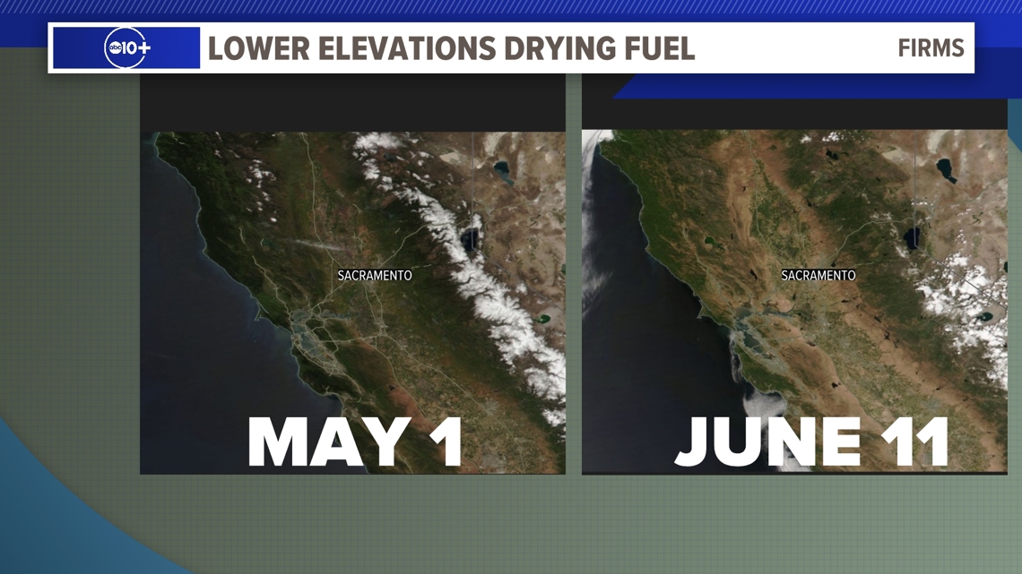
By Saturday, winds will shift and will now blow in from the north. This type of weather pattern is prime fire weather, especially as the summer wears on and vegetation continues to dry out. Satellite imagery shows how dry the state has become since May 1 when there was still a considerable amount of greenery in the valley and foothills.
The gustiest winds and lowest humidity values will occur on Sunday and Monday. Humidity values will fall into the teens and even the single digits for some locations while wind gusts of 25-35 mph. The gusty winds, particularly on the west side of the valley, will increase the potential for rapid fire spread.
So far this year, almost 42,000 acres have burned this year in California, which is almost 20x higher than the same time last year, according to CAL FIRE. The 5-year average during this same period is 27,107 acres, so this fire season is off to a fast start.
Most of the acres burned this year have been in the valley and lower foothills. According to the National Interagency Fire Center, below average significant wildland fire potential is forecast for California through July thanks to the slightly above average wet season. Normal conditions are favored by August and September.